Frequently Asked Questions (FAQ's)
1. Will you do my school project on the Peak District?
No.
2. When was the Peak National Park created?
1951. It is important to realise that National Parks in Britain are essentially planning or zoning devices; all land is owned by someone.
3. Where is the Peak?
There is no such place. "Peak" is a variant on the name of a tribe who once lived in the area. The highest point is technically on Kinder Scout at 636 metres, but this is simply a bump on a plateau and often requires careful navigation to find.
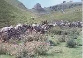
4. When was Carl Wark built?
Good question- no easy answers; dates from 2000 BC to 900 AD have been suggested, but there has never been a major excavation. Maybe it was used as a fort or enclosure more than once.
5. What was the Eyam Plague?
No one knows - when people lived in crowded conditions before soap or antibiotics, many infectious diseases were fatal. The usual assumption - that Eyam was ravaged by bubonic plague - rests upon shaky evidence. Diseases such as measles or flu have been equally deadly when introduced to isolated communities in recent times. Some researchers suggest that the rapid spread across Europe cannot be explained by the movement of rats and that the disease was more similar to Ebola than plague. However, a Channel 4 program shown in Feb. '02, featured the work of an American geneticist, Stephen O'Brien, who found that the D32 gene, which gives a measure of immunity from bubonic plague (and some other diseases) is found in 14% of the direct descendants of Eyam plague survivors but in only 1% of the general population, so maybe the traditional diagnosis is correct.
6. What are the Longdendale Lights?
There are a number of reliable reports of bright lights appearing on the moors above Longdendale and some instances of the whole valley being illuminated at night for a short period. These have inevitably led to some people suggesting flying saucers and others writing them off as aircraft landing lights. Neither explanation is reasonable. Similar lights have been reported from other parts of the world where there are active geological faults make it seem likely that they are some sort of rare natural phenomena: "earth stress".
This is a subject given much space on the net - for example, there is a review of Derbyshire earth lights at:
7. What is the origin of the name "Peter's Stone" ?
Peter's Stone is a mass of limestone which has slipped downhill on a clay layer in Cressbrook Dale . Once called the Gibbet Stone as the bodies of executed criminals were displayed there. In ancient Greek, a rock was called "petros"; the Bible claims that Jesus called his disciple Simon "The Rock" or literally "Peter" in Greek. It is likely that the change from "Gibbet" to "Peter's" Stone is an example of the 19th century effort to erase barbaric or rude place names when guide books and ordnance maps were compiled. In this case the result is to call the site in effect "stone stone" but to link it to the New Testament.
8. I am doing a GCSE project on : "conflict between increasing economic activity and conserving the environment and resources. " using limestone quarrying in the Peak District as my case study. Can you help?
See question 1 !
For a general description of the minerals and their extraction:
and for a more partial view see the CPRE site - focussed on the loss of amenity
Mineral extraction employs around 1500 people in the Peak ( see http://www.peakdistrict-education.gov.uk/Fact%20Sheets/fz16pop1.htm)
or about 1 job in 200.
Maps of quarry locations are available from the British Geological Survey: http://www.bgs.ac.uk/mineralsuk/minequar/industrial/home.html
plus - have a look on the web for the minutes of Hassop and Longstone Parish Councils, which are published and make references to the Backdale Quarry (see 8 above).
9. Where can I go bird watching in the Peak District?
Any of the reservoirs edged by woods are a good bet; an amazing number of migrants are spotted around the Redmires Reservoir, but this is probably a reporting issue because some enthusiastic birders live locally. Have a look at the Sheffield Bird Study Group site:
and the Fat Birder lists all the major sites in the county: FatBirder
It is also worth having a look at the Sorby site:
The Sorby Society must be one of the most the most active natural history societies around and runs lots of visits & walks .
10. How many people live in the National Park? How many miles of drystone walls are there.... ?
Have a look at the "Fact Sheets" in the "Learning Zone" on
11. Do people from Biddulph Moor have Arab ancestors?
There are various accounts of a distinctive group of families on Biddulph Moor, centred on the Baileys who believed they had Arab ancestors. A story first known to have been published in the 19th century is that a group of captives were brought back from the Middle East by crusaders in the 12th century and given homes on Biddulph Moor. A variant on this is that an individual Arab ("Moor") was made Bailey (keeper) of the moor in the same period. There are certainly unusual features in the local church which have been influenced by middle eastern traditions, but there is little solid evidence and DNA analysis has been inconclusive. An alternative is that some minority group - perhaps gypsies - lived in this area, (which would have been a tough, marginal environment in pre-industrial times) and retained distinctive physical features which they or their neighbours explained by reference the crusades and captives. A detailed account is available:
n.b. An area of Berwick-upon-Tweed once had a distinct community of fishermen with a high proportion of settled sailors from Portugal, Spain & France. They were known as the "Greenses Arabs". "Arab" was not a precise term - it meant foreigner, so perhaps "Biddulph Moors" originated in the same way.
12. Are there geocaches in the Peak District?
Yes - have a look at http://www.geocaching.com/seek/cache_details.aspx?ID=18577 . (Geocaching is a kind of treasure hunt which assumes the use of some kind of Global Positioning device to find a container with toys/ trinkets/ sweets in. Participants take one item and leave another).
13. What's happening to the forestry plantations in the Alport Valley?
The plantation ( 500,000 trees, planted in 1928) opposite Alport Castles is being felled by the National Trust (now owners) and the Forestry Commission over a 40 year period; (i.e. there will not be an intensive extraction/ saw milling operation) Replanting, in conjunction with the National Trust & various other bodies, will be with a variety of deciduous trees : oak, birch, rowan, & holly which are probably the natural "climax" tree community. The result will be a much better environment for wild life. The CPRE are keen for something similar to be done with the plantations below Lockerbrook.
14. Is it true that a double sunset can be seen in Leek?
Around mid-summer (21st June) there is - or was - a possibility on a clear evening of seeing the sun disappear behind a hill - The Cloud - from the church of St. Edward the Confessor and for it then to briefly reappear and finally set. It is likely that this phenomenon can no longer be seen from this traditional site because of a combination of tree growth and a gradual shift in the earth's rotation, but some people believe that in the past, when it would have been clearly seen, it was an important religious or mystical site. Similar events can be seen from a number of points closer to The Cloud from the roads immediately north-west of Woodhouse Green at various dates and from the vicinity of Glutton Grange in late June. For an exhaustive discussion of all this see: "The Mysterious Double Sunset" Jeff Kent, Witan Books, 2001 or see:
15. Why is there a memorial for a dog beside the Derwent Reservoir?
Tip was a sheepdog owned by Joseph Tagg, who, though in his 80's, went walking on Howden Moor on 12th December 1953. Mr Tagg died on the moor and his body was not found until 15 weeks later: 27th March 1954. Having apparently survived the worst of the winter, Tip was found starving alongside her master. She was looked after, but died a year later on 16th February 1955 and a memorial stone was erected by the road close to the Derwent dam wall. Tip was actually buried on the moor where her master had died.
David Hey "Packmen, Carriers and Packhorse Roads", Leicester University Press 1980, page 98, quotes the "General View of the Agriculture of the West Riding of Yorkshire", 1799:
"...about Rotherham and Sheffield carts were led by three horses, had narrow wheels, were 7ft long, 3ft 6ins wide, 1ft 8ins deep...."
17. How much do millstones weigh?
I have taken samples, weighed them on laboratory scales and measured their volume by their displacement of water in a precision flask. The results are:
Burbage Edge: 1 cubic cm = 2.41 grams
Millstone Edge: 1 cubic cm = 2.29 grams
average: 1 cubic cm = 2.35 grams
therefore 1 cubic metre = 2,350 kilograms / 2.35 tonnes.
This corresponds well with George Farrar (Quarries) Limited,
(http://www.farrar.co.uk/europe/stones/stones.htm" http://www.farrar.co.uk/europe/stones/stones.htm who quote their sandstone as being 2.4 tonnes per cubic metre.
Therefore a Peak District typical 19th century millstone, with a diameter of 1.8m and a thickness of 0.41m, will have a face area of
(3.142 x (1.8/2)2) = 2.54 m2 . The volume of the stone will therefore be 2.54 x 0.41 = 1.04m3 and so the stone will weigh almost exactly 2.4 tonnes. Similarly a 2 metre diameter crushing stone will weigh 3.5 tonnes and a 0.94m diameter pulp stone will be about 0.5 tonne.
18. Do you know of a book that explains how some of the features in near Alstonefield were formed, specifically: Dove Holes. Reynards Cave & Ilam Rock?
The 1st book to look at is
Classic Landforms of the White Peak - Castleden R., & Green C., 1999, Geographical Association
although only small, (50 pages), it has crystal clear diagrams and is right up to date on processes and landscape development (with the caveat that there is very little evidence of what Britain was like in the Tertiary when lots of Derbyshire landforms developed and I do not think I have ever heard a convincing explanation of Ilam Rock). Pages 24 -30 are largely about Dovedale and it is clearly written with field trips in mind. There is also a twin Dark Peak booklet that would be useful just before a walk on Kinder.
A follow up is
Rocks & Scenery of the Peak District. Ford, T.D. 2002 Landmark.
Trevor Ford is stronger on sedimentary history with a chapter on caves.
19. What is that sign on a building beside the road in Alport all about?
The notice reads: NOTICE TO ALL VAGABONDS FOUND LODGING LOITERING OR BEGGING WITHIN THIS HAMLET WILL BE TAKEN UP AND DEALT WITH AS THE LAW DIRECTS. The english could be improved, but the intention is clear enough! A vital clue is the legal reference on the sign: Vagrancy Act 1824. This was a set of laws passed in response to the large number of soldiers discharged at the end of the Napoloeonic Wars. Many, no doubt traumatised by their experiences, could not find work, were homeless and took to begging. The 1824 Act not only criminalised beggars, including those who exposed their wounds or used children to beg for them, it made loitering an offence and gave the police power to search people they suspected of a crime. This sus law remained in force until the 1980's, when the widespread use of the Act by the police to stop and search young men contributed to the riots in Bristol and London. see pic
20. Where is the "Winking Man"? 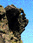
Just north of Leek, on the A53 (the old Roman road to Buxton), Ramshaw Rocks rear up, revealing how layers of millstone grit have been folded and eroded into a variety of shapes. The best known of these is the Winking Man, a profile with a natural hole for an eye. The hole appears to open and close as travellers move along the road below and although this simply the result of a changing viewpoint, the eye appears to wink.