Peak District Routes, Stoops, Pack Horse Ways, Turnpikes.
The first visitors to the Peak no doubt followed paths made by the animals they hunted. The first farmers, in the Neolithic, 5,000 years ago had a culture at least partly involving trade, and they probably established the first long distance routes. Their paths are now lost to us, although it has been claimed that Baslow Bar, the track from Baslow up to Baslow Edge is one of these prehistoric routes.
Just as tenuous is the Portway. A braid of roads and paths runs from Nottingham (or Derby according to taste) across the Peak via Robin Hoods Stride and Fin Cop to Mam Tor and perhaps Glossop and many believe it was a key trade route before the Romans came. A good example of the Portway is the track that runs south from Grangemill (244575).
The Romans settled northern England in the second half of the first century. We know from markings on "pigs" (standard blocks) of lead that they had an administrative centre called 'Lutadorum'. 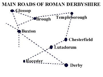 The exact location of this is open to question, but it was probably somewhere in or between Wirksworth and Matlock Bath. Lead was an important source of wealth, and roads and forts were constructed to both pacify the area and protect the lead trade. Many sections of the Roman roads have disappeared, but enough is known to re-create the pattern. Perhaps the best known Roman road in the area are the first 2 miles or so of the A515 south of Buxton, which right on top of a classic dead straight Roman road.
The exact location of this is open to question, but it was probably somewhere in or between Wirksworth and Matlock Bath. Lead was an important source of wealth, and roads and forts were constructed to both pacify the area and protect the lead trade. Many sections of the Roman roads have disappeared, but enough is known to re-create the pattern. Perhaps the best known Roman road in the area are the first 2 miles or so of the A515 south of Buxton, which right on top of a classic dead straight Roman road.There is little systematic information about communications in post Roman times. It is likely that some "causeways" - lines of smooth flagstones wide enough for a single horse date from medieval times, but this was done on a local and limited basis, (and renewed in the 18th century). The best known causeway is that running between Stanedge Pole and the Buck Stone (Grid Ref: 235848): the 'Long Causeway'. . This is traditionally said to be "Roman", but is more likely to have medieval origins. ( It's line is probably dictated by the need to avoid the deep morasses of White Path Moss to the south and the deep peat groughs to the north; deep peat funneled routes onto rides and high points).
There is no doubt that trade went on and although wheeled wagons- "wains" were used most loads in the central Peak were either carried by man or beast, or pulled on sledges. Salt, for example, (needed for pottery glaze, soap making and many chemical processes, 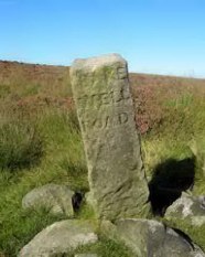 as well as food preservation) had been transported across the Pennines from Cheshire to Yorkshire on pack horses for centuries, giving rise to various "salter" place names, such as Saltergate in Chesterfield. The most common evidence of the tracks used prior to the coming of turnpikes in the 18th century are the long grooves in steep slopes worn by pack horses (that is ponies fitted with wicker panniers into which grain, ore, coal etc. could be carried). In many places these can be seen braiding as impassable sections were by-passed; (e.g. south of Longshaw, Grid Ref:798267). Their sections today are partly due erosion & neglect, but are still too narrow for wains to have been a normal cross-country vehicle, although
  narrow carts may have been in use. A few bridges have also survived unaltered from that period. The best known is near Clodhall crossroad (Grid Ref: 278742); although it has "1742" marked on it, this is thought to be the date at which parish boundaries were confirmed rather than the date of construction. More substantial bridges were needed across the Derwent (a serious barrier in winter before substantial bridges were built). Hathersage and Baslow (where the old ford site can still be seen) had bridges from an early date. The costs of these were recovered through tolls - it cost 6 shillings & 8 pence to take a pair of millstones over the bridge at Baslow in 1500.
as well as food preservation) had been transported across the Pennines from Cheshire to Yorkshire on pack horses for centuries, giving rise to various "salter" place names, such as Saltergate in Chesterfield. The most common evidence of the tracks used prior to the coming of turnpikes in the 18th century are the long grooves in steep slopes worn by pack horses (that is ponies fitted with wicker panniers into which grain, ore, coal etc. could be carried). In many places these can be seen braiding as impassable sections were by-passed; (e.g. south of Longshaw, Grid Ref:798267). Their sections today are partly due erosion & neglect, but are still too narrow for wains to have been a normal cross-country vehicle, although The 17th century saw an increase in trade and travel, and the occasional standing stones used as guide posts (e.g. Lady Cross, a monastic boundary marker, Grid Ref: 270783) were shown to be inadequate.
Ceilia Fiennes rode through Derbyshire in 1697. She travelled when stoops were rare and turnpikes unknown. Describing the descent to Bakewell, she wrote: "...you are forced to have Guides as in all parts of Darbyshire.."
and of the journey from Bakewell to Buxton, " Its very difficult to find the wayes here for you see only the tops of hills..".
see The Illustrated Journeys of Celia Fiennes 1985-1712. Ed. C.Morris. Alan Sutton Publishing. 1995
|
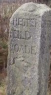
An Act of Parliament of 1697 required Justices to set up guide posts or "stoops" to aid travellers. The Derbyshire Justices did little at first, but finally got going in 1709, and most of the stoops which can be found today were erected in 1709 or in the following decade. (The exception to this is Bradfield parish, where a number of guide posts were erected in the mid 19th century).
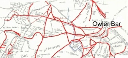
Stoops were necessary not only to find the way in a general sense, but also to navigate the tangled web of tracks which existed in many areas. Big Moor (between Owler Bar and Curbar) is an area of relatively shallow peat, with the very soggy Leash Fen to the south and the steep slopes around Totley Moor to the north. GHB Ward published his survey of "stolen" bridleways on Big Moor - pack horse tracks now enclosed - in the Clarion Ramblers handbook of 1944; the section below shows the northern part of his map: (approx. 4 kilometres east-west; tracks and footpaths marked in red)
The 18th century saw two revolutionary changes in the landscape: enclosure and turnpikes. Enclosure had been going on in southern England for at least 200 years, and was not unknown in the Peak, but the main impact of Enclosure occurred in the 18th century. At the beginning of the century, most moorlands were pastures where all the freeholders in a parish had the right to graze cattle and sheep. This led to relatively inefficient farming, as well as boundary disputes between parishes. Enclosure was a process by which common land was divided up into parcels to be owned by the commoners. They were then required to fence or wall their land by a deadline. In theory, this was an equitable process, but in practice, the legal changes required an Act of Parliament and a gaggle of lawyers. These were only available to the rich and powerful, who made sure that they got the largest share of the commons. 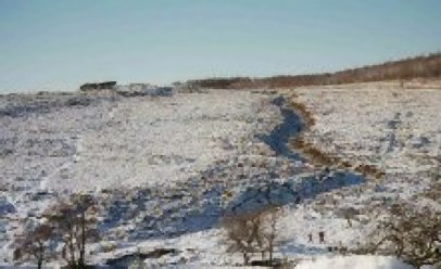
By enforcing wall building, enclosure ended the opportunity for each pack horse train to take a different route across the moors.. Everyone had to follow the roads created by enclosure. By itself this "privatisation" of open country, building walls and defining roads had a major impact upon the landscape. The Peak was also changed forever in mid century by the building of the turnpikes.
Turnpikes were roads built and surfaced by private companies who changed travellers a toll . Saxton's map of Derbyshire, published in 1579 did not record a single highway (public road) in the Peak, and little changed in the following century. In the century after 1732, however, most of the main roads we know today were built, sometimes following existing routes, but often cutting geometrically straight lines across country such as the road from Curbar Gap to Bleak House (Grid Ref:303721). The biggest impact of the turnpikes was to bring the Peak fully into the national economy. Turnpikes and stage coaches meant the well off could plan journeys that were easier, safer and cheaper. By 1787, the Sheffield to London stage completed it's journey in 26 hours, for example. Previously the journey might have taken a week. At a more mundane level, as wheeled transport became the norm, commodities of all kinds could be traded into and across the Peak without the need for everything to be carried on the backs of man or beast, although pack horses did not entirely disappear until the coming of the railways in the 19th century. 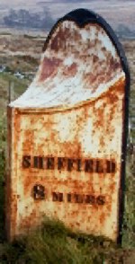
The best "Walks" book:
Copyright @ 2003 Stephen N.Wood. All rights reserved.
This is a Web Counter
This page has been accessed