| home
Ice Ages in the Peak District
For most of the last million years, England has either been covered by ice sheets or has experienced a dry, cold 'tundra' climate. Between cold periods, the climate has sometimes been warmer than today, sometimes similar. The last ice sheet melted only 11,500 years ago, and it's influence can still be seen in the landscape.
Unlike North Wales or the Lake District, where the effects of glacial erosion dominate the scenery, the Ice Ages have left more subtle marks in the Peak; the main ones can be listed as:
Process
|
Result
|
Example
|
Rock, ranging in size from microscopic particles to boulders carried in moving ice streams.
|
Clay ("head") left behind when ice melts
|
Sections of Shining Bank Quarry (229650).
Glacial erratic in Chatsworth gardens.
|
Rock dust left by melting ice dries and is blown by the wind
|
"loess" accumulations - sandy soils.
|
Fields south of Winnats pass & much of limestone plateau.
|
Advancing glaciers
|
Rivers dammed, resulting lakes overflow & create new channels, re-routing rivers
|
Derwent at Calton Lees (Chatsworth)
|
Melt water inside glaciers
|
Melt water channels whose course is determined by the ice and water pressure.
|
Roosdyche, Whaley Bridge. (Grid Ref: 015810)
|
Melt water outside glaciers
|
Valleys & caves eroded by melt water streams
|
Winnats Pass - perhaps!
|
Seasonal melting of soil above permafrost
|
The mud layer above the icy permafrost crates a lubricated surface - boulders slip down gentle slopes.
|
Boulder stream in fields below many Edges e.g. below Froggat Edge at (Grid Ref: 244770)
|
Complete thawing of deep permafrost
|
Landslips released.
|
Alport Castles (142915)
|
The dynamics of glaciers and ice sheets are difficult to envisage when standing in the English countryside today, but a visit to an Alpine glacier provides an opportunity to see the chaotic jumble of ice and rock at the snout and melt water in crevasses and englacial caves which characterizes melting ice. The main phase of an Ice Age must have been more daunting : intense cold, freezing the earth hundreds of metres down, so much of the world's water locked up ice that sea levels were far below those of today; (our ancestors walked across what is now the North Sea), and the build up of perhaps a mile thick layer of ice (compacted snow) over much of northern Britain.
Over most of the Peak, snow built up, was compacted to ice, but resting on gentle slopes, just stayed where it was until it melted. As a result, relatively fragile tors like Mother Cap (252805) were left in place.
The Times: 4th Jan. 2001:
Charles Harris of Cardiff University reports to the RGS annual conference that alpine permafrost temperatures have risen up to 1 degree C in the last 15 years. He says this will cause an " ..increased frequency of slope failures, landslides & rock falls...". Just what happened in the Peak at the end of the last Ice Age.
|
At the end of a cold period, when the surface was exposed, boulders skidded downhill by the process of solifluction (slipping in the melted surface of permafrost), smaller fragments were swept away by melt water, and tors were eroded by sands blown by the dry tundra winds, so although modified, much of the landscape retained it's pre-Ice Age shape.
In more mountainous areas, however, the ice sheets slowly flowed down from the highest ground, creating glaciers which could flow for hundreds of miles before reaching the sea or melting, just as they do in Antarctica or Greenland today. One of the streams of ice from the Lake District flowed south and reached the Peak near Buxton. There it divided, the main stream heading south, leaving fragments of Lake District rocks all the way to Ashbourne and beyond. A secondary stream went east, passing over what is now Bakewell, where it split again into a south easterly stream which overrode the Matlock area and an easterly steam which reached the Derwent valley.
The easterly stream is of interest because it almost certainly dammed the original course of the Derwent, which originally flowed at a higher level and took a turn south west near Baslow and flowed down what is now the Wye valley south east of Bakewell. The easterly ice stream blocked the original course of the Derwent at some phase, leading to the creation of a lake in the area north of what is now Chatsworth. The lake eventually filled (perhaps with summer melt water?) and spilled over the water shed which then existed at what is now Calton Lees (261685). The course of the Derwent was thus diverted and eroded a new valley directly south. The landscape evidence we see today is the wide valley of the Wye and the narrow valley of the Derwent between Chatsworth and Rowsley where it suddenly opens out again. The key to the explanation are glacial debris ("erratics"), including boulders from the Lake District, found near Bakewell, indicating a stream of ice moving south down the west side of the Pennines and then turning east, perhaps because of ice streams from north Walesl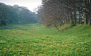
A series of landscape features which have generated ideas on their origin is the Roosdyche complex; (Grid ref: SK015810). What is seen the on the ground are braided channels running roughly parallel to the valley side. Because they go up and down, it is clear that were not formed by running water in any normal manner. Due to this, they were once believed to be ditches dug by giants or Roman race tracks. It is easier to understand their origin if melt water has been seen gushing out of a glacier. Inside a mass of ice, water often flows inside enclosed tubes (ice caves when empty). These tubes have developed as melt water follows cracks in the ice. Where there is a sufficient head of water (not uncommon in a glacier during summer!), there will be sufficient pressure for water to flow up through cracks. Englacial streams are therefore liable to erode channels that reflect conditions inside a long lost ice sheet. The Roosdyche channels show where englacial streams touched the valley sides and eroded the rock like any other debris laden torrent. Because the streams were enclosed by ice, (i.e. the channels we see today are simply half of the original tube) and under pressure, highly irregular stream beds were left behind.
Copyright @ 2003 Stephen N.Wood. All rights reserved.