Peak District Geology
The landscapes seen today in Derbyshire are the result of the characteristics of the 3 main rock types found in the area:
* limestone dissolves in rain water, cracks are enlarged and so surface water soon disappears underground;
* gritstone absorbs water very slowly and so has rivers and bogs on it's surface;
* shale is physically weak, but, if undisturbed, it forms a barrier to water;
in addition:
* the rocks have repeatedly been folded, cracked and torn.
A cross-section across the southern Peak District shows how rocks, originally laid down in horizontal layers have been folded and then eroded:
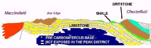
Limestone
|
|
Typical landscape:
Limestone underlies much of the southern Peak District and displays many characteristic features: plateaus dissected by steep valleys and gorges, caves and dry valleys. Further north, large areas of bare rock are found on high ground (famously around Malham), but Derbyshire received a covering of wind blown dust at the end of the ice ages that provided the basis for soils over the whole area. Because rain water dissolves limestone, little surface water occurs naturally on limestone, and large volumes of water flow through cave systems, but where the water table is high enough for streams to flow above ground (as opposed to caves and cracks below), the calcium rich waters nuture a variety of wildlife - probably best seen in Lathkill Dale. Limestone scenery
|
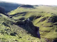 Cave Dale, nr Castleton
|
Formation:
The story therefore starts with a tropical sea around 350 million years ago : the geologists' "Carboniferous" period. In seas that were warm and free of silt, the hard parts of (mostly microscopic) invertebrates built up on the sea bed and formed a limey mud. Something similar can be found in the Caribbean today. Normally the shells and skeletons decayed and fell into microscopic pieces, but occasionally waves or current buried a complete animal, and, lost to the processes of destruction & decay, they reappear today as fossils - usually crinoids, but occasionally trilobites and shellfish. A wide variety of minerals were deposited in cracks and cavities in the limestone after it had formed, but whilst it was still deeply buried. Lead and fluorspar are the most economically valuable of these minerals. See Lead Mining
|
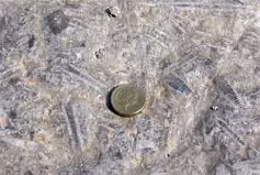 Crinoids - Dovedale
|
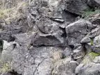
Special case 1: Dolomite
In some areas, magnesium was carried by ground water into the limestone layers, (probably by highly saline water lacking dissolved oxygen, but the exact process is unknown). Dolomite is much more resistant to erosion than ordinary limestone, and outcrops at a number of points between Carsington and Hartington; a good example is Rainster Rocks, near Ballidon. The rock weathers unevenly, with many ridges and holes
|
 Dolomite - Rainster Rocks
|
Special case 2: Volcanics
From time to time small volcanoes pushed up hot lava into the limestone, sometimes flowing out over the sea bed. The lava cooled to became basalt. This outcrops in a number of places, but has generally been quarried away either commercially (e.g. Calton Hill) or by geology students (columnar basalt in Cave Dale). One place it can be seen is on the A6 between Buxton and Bakewell, roughly opposite the old bobbin mill below Great Shaklow Wood: Black Rock Corner.
|
 Basalt - Black Rock Corner
|
Shale
|
|
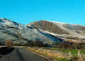
Typical landscape:
Shale underlies a significant part of the Peak District, but generally does not outcrop or produce significant hills. Shale grit, however, an intermediate between true shale and grit, does have some resistance to erosion and this is demonstrated dramatically to the north of Castelton at Mam Tor. (Technically, the upper layers of Mam Tor consists of
|
 |
Formation:
The clear seas in which limestone formed were eventually changed radically about 300 million years ago as rivers carrying debris eroded from an emerging mountain range far the north carried mud and sand down to their deltas. As the deltas spread out, they covered the limestone, first with mud, and then, as they advanced out to sea, with grit. The silt and mud were buried and eventually become shale: usually brittle and full of cracks, but impervious to water where it is undisturbed. Deposition was strongly influenced by tides and currents, leading to clear layering and limited adhesion between strata. Later, earth movements, both tectonic and local caused pronounced faulting and folding in shale.
|
 Shale - Woodlands valley
|
Gritstone
|
|
Typical landscape:
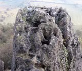
Gritstone is a coarse sandstone, porous, but strongly cemented and resistant to erosion. It forms plateaus when strata are horizontal and scarps - "edges" - where anticlines have been eroded. Gritstone reflects both it's original formation, with weak and strong layers, and later faulting that has led to big variations in horizontal strength. The net effect is that tors can be found in many locations, where 5 metres or more of grit has been removed, leaving isolated towers. (These formed prior to glaciation, seem to have been largely unafffected by burial under ice sheets, but were eroded by winds blowing grit in the arid, cold conditions that existed at the end of the ice age). Gritstone scenery
|
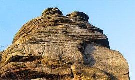
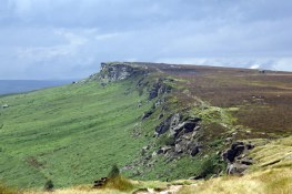 Stanage Edge
|
Formation:
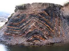
Around 300 million years ago, a range of mountains were pushed up to the north and an immense Amazon or Mississippi sized river spread it's delta over much of what is now England (and Holland and Belgium). As the delta built itself closer, sand and grit covered the shale and limestone layers. This was a dynamic environment with tides and strong currents which often moved and re-sorted the sand banks and bars of the delta; these layers ("units of deposition") can often be seen in exposures such as the Roaches or Stanage Edge. The most well known use use of millstone grit is for millstones.
|
 Layering - Millstone Grit
|
Limestone and gritstone landscapes are considered in more detail in their own sections:
Geological History - Time Line
Years Ago:
|
Event
|
I Million
|
A series of Ice Ages begin, separated by periods with a climate similar to that of today. In early glaciations, the Peak was covered by ice hundreds, perhaps thousands, of feet thick - like modern Greenland. The ice front of the last Ice Age came no further south than Leeds; the Peak underwent a period of intense, dry cold: a tundra landscape. As the deeply frozen surface layers thawed at the end of the last ice age, landslips were released and boulders slipped downhill on buried ice layers - examples can be found below Baslow & Froggat Edges.
|
60 Million
|
Area uplifted out of the sea. The rock layers which had accumulated over the previous 200 million years begins to erode away, eventually leaving the landscape we see today.
|
280 - 60 Million
|
Derbyshire at or below sea level. Long periods of deep submergence left at least a kilometre of rock above the Gritstone. Minerals, including lead, dissolved in groundwater (often under pressure and at high temperatures), were deposited in faults and caverns.
|
280 Million
|
Tropical swamps, occasionally flooded by the sea. The drowned soils became fireclays, tree ferns became coal. Britain started to drift slowly north, part of a global shuffling of land masses.
|
300 Million
|
Derbyshire was in the delta of an immense river which dumped sand and mud over much of what is now England. Sorted by currents and tides, the muds deposited in deeper water became shales, and the sands gritstone.
|
350 Million
|
Britain was far from it's current position, south of the equator. Derbyshire was covered by clear, warm seas, teeming with life. Limey muds and the hard parts of sea creatures built up on the bottom; limestone formed as these sediments were buried, compressed and heated.
|
The best Peak District "Walks" book:
|> Copyright © 2003 Stephen N.Wood. All rights reserved.