Millstone images 5 - Quarry features Home Millstone page
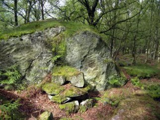
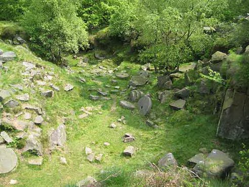 A small quarry - a delph - on the west side of Padley Gorge. Likely to be an 18th or early 19th century day working site.
|
|
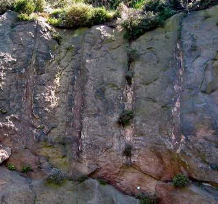
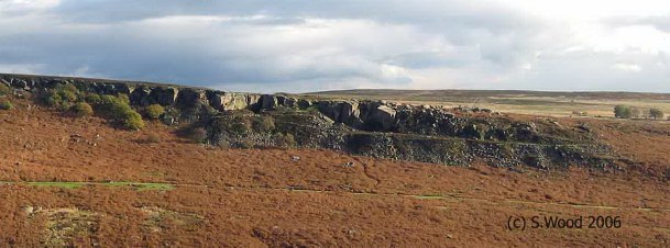 Wildmoorstones quarry (Burbage, near Fox House) - a company quarry from the 19th century, perhaps even the early 20th
|
|
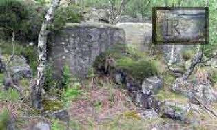 |
Building foundations near Surprise View (SK24827 81596). The insert shows an inscription: "IR" on one block. There is no evidence of who used this building or when, but the massive size of the blocks (around 30cm cubes) suggests quarry workers. Dozens of millstones at all stages lie within a 100 metres.
|
 |
A shelter below Gardom's Edge - one wall was a massive boulder and the lines of the roof was chiseled out; no doubt stone tiles or perhaps even lead, originally filled the groove(s). This seems an obvious site for a millstone workers hut, a little too elaborate for a shepherd or lead bole workers.
|
 |
Millstone smithy site - below Gardoms Edge. Excavated in the 1960's, there were no directly datable remains, but coal, cinders and charcoal were found, so a smithy with a brazier seems likely. Radiating grooves in the rock at shoulder level are consistent with chisels being sharpened by rubbing them up and down. There is also a depression likely to have been a quenching trough and (perhaps) slots on the top of the rock where rafters were placed to make a lean-to.
|
 |
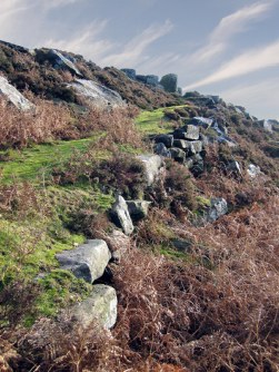
Dobb Edge - extensively quarried when the area was owned by the Duke of Rutland prior to the early 19th century, when it became part of the Chatsworth Estate. Radial grooves similar to those at the Gardom's smithy, assumed to be the result of chisel sharpening.
|
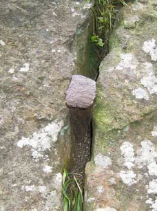 |
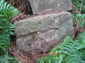
Iron wedge, approx 100 mm long, Yarncliffe (SK45255 79388 - Cardinal Crack). This is less than 2 metres off the ground, so it is unlikely to be protection placed by a climber; it's placing is consistent with an attempt to wedge a block sideways. Quarrying carried on here well into the 20th century, although not for millstones.
|
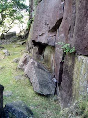 |
It is difficult to work out the methods used to quarry large blocks in the past. The large number of overhangs suggest that blocks were often removed progressively up from the bottom of the edge, especially in early times, but it is rare to find clear evidence of this. One example the process can be seen is below Gardom's Edge, where there is a block that appears to have been levered or wedged out immediately below a small overhang.
|
 |
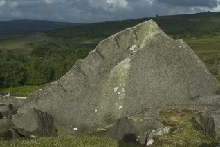
The tops of Edges also show evidence of quarrying, possibly from a later period, when steel tools where in use. The best example is here on Curbar Edge: a line of small pits marking out where someone planned to quarry a large block.
|
 |
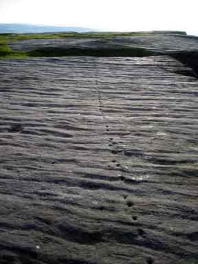
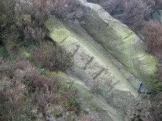
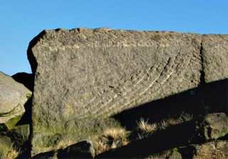
The next stage after marking out was to cut a V shaped channel with picks. The regular deeper marks are probably where wedges were driven in to the bottom of the "V". Many half channels are left in parent blocks, as here on Curbar Edge.
|
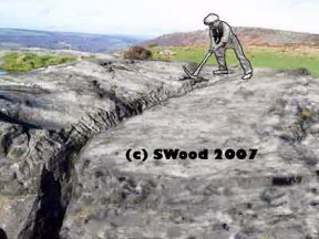 |
A reconstruction of the "V" channeling process; after a line of weakness was created, wedges would have finally broken off the block.
Until early 2008 I belived that no complete channel remained, but then looked on the uphill side of a large block used for bouldering below Curbar Gap...
|
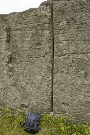 |
And there was a complete vertical groove, over 2 metres long, ready for wedges. I must have walked past the other side of this boulder dozens of times! A large block, several cubic metres in size would have been created had this groove been driven, but no doubt smaller blocks of the best stone would have been later split off for millstones etc. There are no millstones close to this site, though there are some stones in delphs in Curbar Edge above the site.
|
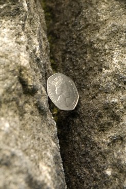 |
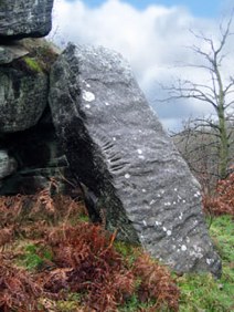
A detailed look in the groove with a 50p for reference. The age of the groove is impossible to determine, but it looks heavily weathered and on this basis my guess is that it dates back to the 18th century or earlier.
|
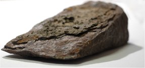 |
An iron wedge found at a quarry site near Stanage End: 12.5cm x 7cm x 3.5cm. In the 18th & 19th (and sometimes in the early 20th) centuries wedges like this were used to split gritstone. It is likely (though not certain) that wedges like this were used in V grooves like those shown above.
|
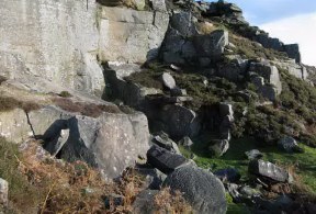 |
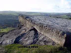
A quarry site on Curbar. This has clearly been worked down from the top, forming a series of large steps.
|
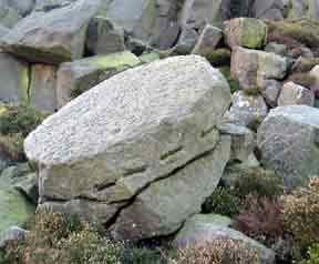 |
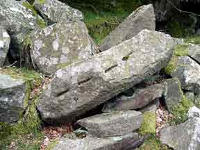
Wedge pits on a roughed out boulder, NE side of Carl Wark (SK2601 8132). This "stitched" effect is found where the mason planned to drive wedges and split the boulder.
|
 |
More wedge pits, this time on Gardom's Edge. An old technique to split rock was to place wedges of dried wood in slots like these, then wet them so that the expansion of the wood split the stone.
|
 |
Hand drilled hole, Wharncliffe. approx 18 inches long. In the 19th century, and possibly earlier, bouklders were split by placing a pair of thin, dished wedges ("feathers") in a hole then driving a large wedge between them (the "plug"). There is no sign of blasting, and the hole seems too deep for wooden wedges, so perhaps this block was split with a plug and feathers.
|
 |
Hand drilled holes, Wildmoorstones (Burbage). Probably used to place wedges of some kind. (Machine drilled holes are much more regular in angle, straightness and diameter).
|
 |
Hand drilled holes at the extreme southern end of Wildmoorstones (Burbage) above Toad's Mouth. Like many old features this appears to be a large boulder rather than a block prised from a quarry face.
|
 |
Machine drilled shot holes on Millstone Edge, where quarrying continued well into the 20th century. The block was removed by explosives - the shattering is clearly seen about half a metre below the upper surface.
|
 |
Sweeping pick marks at Stanage End - a block has been split off and a new face has been cleaned up. Similar pick sweeps can be found in lead workings.
|
 |
Quarry track on Curbar Edge. Inclines like this must have been the normal route to haul building stone and millstones up onto the moor for the long trek to Bawtry and a barge on the River Idle.
|
 |
A feature below a quarry site on Gardom's Edge: a series of blocks have been aligned in a curving path down the steepest part of the slope. What is unusual here is that the lowest part of the original track must only have been inches wide: the blocks form a V in cross-section. This cannot have been for a wheeled vehicle and is narrower than any pack horse track. An interpretation that makes sense of both the cross-section, and it's upper terminal below a cliff, is that this was a chute intended to guide millstones being rolled down towards Baslow. Elsewhere below Gardom's are short boulder alignments that can be interpreted in the same way, but none are long enough to rule out chance arrangements, so this feature is unique.
|
Copyright @ 2008 Stephen N.Wood. All rights reserved.