| home
Peak District history : Anglo Saxons to Present
During the 6th century, an Anglo Saxon group, the Pecsaetan, moved into the Peak. Previously, the area had been inhabited by Celtic peoples. The relationships between Anglo Saxons and Celts (Britons) are problematic.
There is good evidence of famines and an especially virulent form of bubonic plague right across Europe in the second half of the 5th century. It is possible, therefore, that the Pecsaetan moved into a virtually empty territory; the low incidence of Celtic place names provides some support for this.
(see Peak District Place Names ).
There are few large features in the landscape which can be linked to the Anglo Saxon period. The most likely are the Grey Ditch ( 182813), which runs across the valley of the Bradwell Brook just north of Bradwell and the Bar Dike (247947) on the edge of Broomhead Moor. Their function and dates are unknown. Perhaps they were the creations of local war lords, partly fortified boundaries, partly symbolic markers - and no doubt convenient points to extract tolls from travellers. It is just possible that these earthworks date from the reign of Offa (late 8th century) who was king of Mercia. The border between Northumbria (which covered most of northern England) and Mercia (which covered most of the English Midlands) ran east-west across the northern Peak, and it is possible that Offa's government trialled a northern version of Offa's Dyke.
At first, the Anglo Saxons had Pagan beliefs and the burials of leaders were in the form of barrows. Most of these are in a band running from Buxton to Ashbourne. The best known is at Benty Grange (146642). Christianity became dominant by the end of the 7th century, and their artifacts reflect changing times; (the Benty Grange helmet, which can be seen in Sheffield Museum, combines Pagan and Christian symbols). Perhaps one of the most interesting is the cross in Eyam churchyard, which shows a lamb - an ambiguous symbol, both Pagan and Christian, but typical of Anglo Saxons "playing safe" in religious matters. As the Lamb on a Cross was forbidden by the Church in 692, the monument is unlikely to be later than the end of the 7th century.
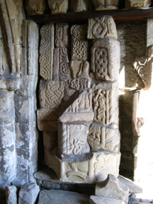
Another echo from the 7th century is the lid of a burial vault displayed in Wirksworth church. The Stone shows a series of Christian images. (see The Wirksworth Stone)
Coffin covers etc in the doorway of Bakewell church -likely to be Anglo Saxon.
 |
At the end of the 8th century, coastal raids by various Scandinavian groups, generally known as the Vikings, began. Raids increased in length and intensity until by 878 Alfred, king of Wessex was driven to skulking in the Somerset marshes. By the end of the 9th century, however, the invaders had been beaten back behind a line stretching from London to Chester. The position of the Peak at this time, being close to the northern limits of Alfred's control, is not clear, although the Danes took possession of the Wirksworth area in 874, so it is likely to have been dominated by the Danes to the east and the Norwegians (who occupied Lancashire from bases in Ireland) to the west. The incidence of Norse place names, however, suggests that they did not settle in the Peak to any great extent. A drive from say, Bakewell to Lincoln, illustrates this: names ending in "..thorpe" and "..ing", typical Norse endings, are relatively rare in the hills but common in the flat and fertile lands to the east. Norsemen may well have grazed their sheep on the northern moorlands, however, as "...grain" was a Norse word for stream, and these are common around Bleaklow. By the early 10th century, most of England, including Derbyshire, was under a single king again, but under attack once again from new Viking armies, first from Norway, later from Denmark. Although a century of raids and minor invasions followed, no major cultural changes occurred.
The next event we can see evidenced in the Peak landscape is the Norman conquest of 1066. It was several years after 1066 for the Normans to gain full control of the whole of England. The first stage of Peveril Castle (SK150827) was built after the conquest by one of William's court, (William Peveril) who had been given the lordship of the Peak - which meant the duty to subdue and right to tax. The exact date is not known, but a curtain wall encircled the site by 1086. A widespread revolt in the north of England in 1080 was soon put down, but a number of fortlets were built in order to police the countryside. One of these fortlets was Pilsbury Castle (SK114639).
The Domesday survey reported much of the northern Peak "waste". It is not clear whether this was the result of the lethal suppression of resistance or just that it was not farmed. In either case, in an age when kings delighted in hunting and needed to secure sources of food for their courts, this was welcome news. The high ground was declared a royal "forest" - a hunting ground with it's own legal system.
Peak Forest was bounded by the Goyt to the west, Longdendale to the north, and the Derwent to the east. The southern boundary ran east-west through modern Buxton. It was divided into 3 administrative districts which joined on the watershed west of Edale at Edale Cross (SK077861).
The southern Peak was came under the influence of the monasteries during the 11th century. Through gifts and purchases monasteries acquired farms - "granges" - which generated cash and supplies for the parent institution. The 19 parent houses were mostly in Derbyshire (e.g. Burton) and Yorkshire (e.g. Beauchief), but were as far afield as Dunstable and Louth. Example of "grange" names : Boosley Grange (069625), Newton Grange (SK165535) Gratton Grange (SK208618). Outlying shelters for herdsmen (the Peak was used to ranch horses and cattle) were called "booths" and these medieval names are preserved in names like Hardings Booth (SK068646) & Upper Booth (SK103853).
The clearing of land for agriculture was a communal activity on land ultimately owned by a feudal lord or the crown. Farming in medieval was consequently a communal activity. Large fields were divided into strips which were allocated to different individuals each year. Ploughing was done with teams of oxen. As cattle are poor sources of traction, relatively large teams had to be used, and turning the plough was a difficult process. It was easier to plough a curving strip with oxen than a straight one and strips often developed a reversed though flattened "S" shape. As common lands were enclosed, one or more strips were enclosed and the ox plough curves were fossilised. The effect is better seen on the ground than on the map, but good examples are east of Bradwell (168802) or south of Brassington (225537). Outstanding examples of preserved individual field strips are north of Middleton (282564).
The 12th century saw the encroachment of agriculture into the Peak Forest (the Forest Law was only rigorously enforced in the century after the Conquest,
Peak Forest 1 - by 1251 the fines for "assarting" - clearing woodland for agriculture- had become standardised and were essentially rents. Deer (and wolves) were still in the area, but the Forest Laws were not enforced strictly and many of the poachers named at "Eyres" - Forest courts - were from the aristocracy and not subject to effective control.
|
although it retained a legal existence until 1674). The development of agriculture was allowed by a climate slightly warmer than today's and driven by population growth. By the early 14th century many areas were cleared of woodland - preserved in "..hey" names such as Cow Hey (173935). This period of expansion came to a sudden halt with the outbreak of a particularly virulent form of plague in 1349: the Black Death. At least one third of the English population died, perhaps half. Whilst there is argument about numbers, there is no doubt that the effect on economy and society was radical. Large areas went out of cultivation, left as pasture to this day, (the climate had started to deteriorate in the 1330's) and villages were abandoned ( e.g.Conksbury (208658)). Ridged medieval field strips can be seen in many places in the limestone area, especially as snow melts and slight differences in height are picked out. Examples can be seen north of the road from Rowsley to Haddon or in the fields around Tissington. (n.b. Ridge and furrow cultivation seems to have been limited to fairly flat ground and hardly ever occurs above the 300 metre contour). One place which remains as a reminder of the 14th century is Tideswell church, which was built on revenues from lead and wool between 1320 and 1370.
Early enclosure - walled medieval strip fields. Chelmorton
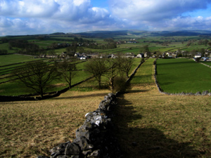 |
The Reformation was, in part, a process for transferring the wealth of the Church to loyal subjects of the Crown. Although a long story in itself, the Cavendish / Chatsworth estate serves as an example of this. This wealth was initially used for building up the mining and property assets of the estates, then later to enhance family prestige: the creation of open parkland around Chatsworth itself (clearing 3 small villages in the process) and the promotion of Enclosure Acts. Enclosures were the legal basis for converting land held in common by a parish to a series of private holdings. The Acts were expensive to draft and promote and so were under the control of the already rich and powerful. Those who were given land by an Act had to wall or fence their land to a minimum (and expensive) standard. The result was that the poor generally were entitled to little and tended to soon lose what they received. The net effect was to create hundreds of miles of walls around fields owned by great estates. Enclosure of open fields close to villages had started in the 16th century, but the process gathered pace in the 18th century so that by it's end virtually all the walled fields we see today had been created.
Peak Forest 2- the remnant of the Norman royal hunting ground stretching west from Casteton & Hope to Flagg and Glossop still existed as a legal entity, though not a practical reality, in 1634. In that year Charles I agreed to a petition to allow the Forest to be enclosed: finance was the Crown's main problem and when Leicester Forest had been enclosed in 1628 the king had gained 1/3 of the land, which he promptly sold; (commoners received the remainder). No doubt Charles expected something similar from the Peak. By the end of 1640 the initial survey had been undertaken and the remaining deer killed. Then in 1642 outbreak of Civil War threw the process of survey and enclosure into disarray. A period of casual enclosure then followed, and when the restored Duchy of Lancaster tried to carry out new surveys in 1675 there were threats of violence from those in possession of the land - who often claimed to have "lost" their documentation . Legal settlement of ownership took until 1712, and it is possible that the status of some mineral rights have still not been finalised!
(see DAJ 1977: "Commons and wastes..." Sir R. Somerville.)
|
The 16th and 17th centuries saw an expansion in the scale of lead and copper mining (see Peak District Lead Mining) as Britain began to industrialise. Major change occurred in the 18th century, with the application of a new type of capital - the joint stock company. Companies funded not only long term capital works like soughs to dewater mines, but turnpikes (see Peak District Routes, Stoops, Pack Horse Ways, Turnpikes.), textile mills (which needed water and water power) at Cromford, Bakewell, Litton and Cressbrook and developed Buxton and Matlock as tourist destinations.
The potential of steam for transport was realised early in the 19th century and investment flowed in the direction of railway promoters as readily as it has done to internet retailers in recent years. The first railway across the Peak ran from Cromford to Manchester via Buxton and was completed in 1830. In mid century a second line was built from Buxton past Litton and Cressbrook Mills to Bakewell and the Derwent valley to rejoin the older line at Cromford. It was this railway that crossed Monsal Dale and prompted Ruskin's comment that it meant " every fool in Buxton can be at Bakewell in half an hour and every fool in Bakewell at Buxton". Today sections of both are left as cycle tracks & walkways. The next major trans-Pennine railways were those that ran through Longdendale and the Woodhead Tunnel in 1847 and the last (and the only one still open) was Sheffield-Manchester via the Totley and Cowburn (Edale) Tunnels in 1894.
Reservoir building in the Peak started in the mid 19th century with a string around the fringes of Sheffield and the chain up the Longdendale valley. The biggest reservoirs were built in the 20th century : Howden and Derwent by 1916, Ladybower in 1945 and Carsington in 1992.
Another major landscape change is the development of large scale quarries near Buxton and Castleton. Quarries have existed for centuries, of course, but the limestone quarrying of the second half of the 20th century was on a far larger scale. (see Limestone Landscapes in the English Peak District )
Completely new to the last 50 years is the evolution of the Peak as a recreational destination for millions in cars. The significance of the landscape was recognised by the creation of the Peak National Park (a planning authority, not a land owner) in 1950, but the growth in car ownership and the resultant problems of pollution and parking are yet to be resolved.
Copyright @ 2003 Stephen N.Wood. All rights reserved.
This is a Web Counter
This page has been accessed
http://www.together-now.co.uk/