| home
Stone Age to Anglo Saxons : Querns, Romans, Stone Circles, Megaliths, the Portway.
Modern man probably first reached Britain 300,000 years ago, but it was not until the end of the last Ice Age, about (12,000 years ago) that people came to the Peak area in any number. Flints (arrow heads, axes & scrapers) have been found at many locations can be dated to 9-10,000 years ago. These 'Mesolithic' peoples were probably the first to modify the natural landscape, by burning woodland to trigger the growth of grass and attract grazers such as deer and wild horses; archaeologists are now seeing this as the beginning of a kind of ranching. A hill side site at Unstone, north of Chesterfield, has yielded scatters of Mesolitic flints that may record some of the earliest hunters in Derbyshire.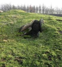
The impact of the first arable farmers, however, about 8,000 years ago, started a process which transformed a landscape dominated by woodland or (on the highest ground) scrub, to one dominated by agriculture. The Neolithic farmers produced surpluses which enabled them to have complex social structures and food stores which created enough time to build large ceremonial structures.
Neolithic remains are of one of two types : tombs and large stone circles. The tombs are enigmatic, having received the attention of both natural erosion and treasure hunters for at least three millennia. The most prominent is Minninglow (ref.: 209573; n.b. no public access) which is placed on a hill top visible for miles around. All that remains today are massive limestone slabs,(left) but it is almost certain that they were originally covered by a mound of earth. It is not known how Minninglow was used, but excavations elsewhere suggest that tombs like this were used over a long period to house the bones of several, perhaps many, generations, whose bodies had first been exposed elsewhere until only a skeleton (perhaps only skulls and long bones) was left to be interred.
Stanton Moor has burial mounds, stone circles and a variety of other features in a small, easily visited area. It also attracted would-be druids and protesters against the plan to destroy part of the plateau by quarrying in 2002-3, finally stopped by legal action by the Peak National Park.
|
It is a curious paradox that whilst Stonehenge is known world wide as a Neolithic stone circle, Arbor Low (SK160636) although on a similar scale, is almost unknown. The key difference is that all the stones at Arbor Low are lying flat on the ground. Excavations have failed to find pits in which they once stood. Perhaps they were only raised on special occasions, or perhaps their significance was sufficiently expressed lying down.
It was thought at one time that the first farms were on limestone, and the spread of farming to gritstone areas was then due to population pressure, and analysis of pollen trapped in mud and peat generally supports this idea. However, analysis of artifacts (pottery, flints etc.) does not support this hypothesis. No doubt the detail of local soils and drainage varied  sufficiently then, as now, to allow individuals to make their own choices.
sufficiently then, as now, to allow individuals to make their own choices.Around 4,000 years ago, a significant change occurred. This is marked by the appearance of bronze tools and weapons, and so is traditionally called the "Bronze Age". Flint tools continued to be used for day to day tasks, however, bronze was reserved for high status weapons etc. The real changes in this period were developments within and between communities. Burials now often consisted of cremated remains in urns, or beakers, generally marked by a cairn or mound. Many examples can be seen on Stanton Moor. These "Beaker People" were farmers, but may have had a more stratified society, with big mounds for chiefs (e.g. Wet Withens : 225790) and small ones for lesser folk (e.g. east of Gardom's Edge: 274733). It was once thought that the Bronze Age was relatively peaceful, but now that the lowest levels of the Mam Tor (128835) hill fort have been dated, it is clear that defended sites were needed. A fascinating enigma is Carl Wark (see picture below; grid ref: 259814) which was clearly a hill fort at some time, but it has not yet been dated. A natural defensive position, it may have been used in several periods. Considerable work has been done on Gardom's Edge in recent years; this seems to suggest that the enclosing wall was a ceremonial feature rather than for defense or a stock corral.
Most of the stone circles in the Peak are from Bronze Age times. Perhaps the best example of a true circle is on Froggat Edge (249768) where an earth bank has smallish stones set in it. Most circles are in fact elliptical or egg shaped - probably the result of an attempt to make the circumference exactly 3 times the diameter. A good example of this is the main circle on Stanton Moor (248632).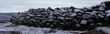
In most of Britain, the Iron Age can be linked to cultural influences from what is now Belgium, France and the Netherlands, that bought iron tools and weapons, coins and distinctive pottery. After about 2,500 years ago, most of Britain was divided into kingdoms, often at war with each other but with trade links to Europe.
The problem is to identify Iron Age sites in the Peak. It is known that the climate was cooler and wetter than it had been in the Bronze Age, evidenced by an increase in the rate of peat formation on the high moors. No doubt life was tougher for farmers and fewer crops were grown. It was once thought that hill forts like Mam Tor, Higgar Tor (257820) and Carl Wark were the Peak District representatives of the Iron Age hill forts found in much of England. No unambiguously Iron Age finds have been made at these locations, however, excavation at Mam Tor has revealed Bronze Age remains. Carl Wark remains a mystery and has been tentatively dated to points from the Neolithic (an orientation to Miininglow has been claimed), to the Medieval....
There can be little question that the Peak was inhabited, however, because when the Romans colonised Britain (ordered by Emperor Claudius in 43 AD) they clearly felt a need to build forts near Glossop (009951), Brough (182827) and Chesterfield (Burger King site). Successive buffer kingdoms were occupied and by about 80 AD northern England had been pacified. A period of colonial rule which lasted over 200 years began. The Roman strategic interest in the Peak was lead and a number of old workings have been claimed as "Roman" (but none confirmed). Pigs (standard blocks) of lead marked with "Lutadorum" as their place of origin have been found in a number of locations in England; the location of this place has never been determined: the Wirksworth - Matlock area is a possibility, although Roman foundations found near Carsington (now under the reservoir) are a strong candidate.
CARSINGTON = LUTADORUM?
Excavations under what is now the centre of the Carsington Reservoir in 1979-80, (roughly opposite Shiningford Farm) revealed a number of Roman buildings, one with some kind of heating or drying system and fragments of lead ore. Close to the line of the Roman road from Buxton to Derby and downhill from the richest lead mining areas, this would have been a good location for lead ingots to have been collected and wholesaled.
(see DAJ 1981, "Excavations at Carsington...", Ling & Courtney).
|
Excavations of Romano British field systems at Roystone Grange (201567) and North Lees ( 233837) confirm that the area was also farmed in Roman times. Finds of pottery have been made in many locations scattered across the White Peak and East Moors. However, apart from their forts and the lines of their roads, there are few reminders of Roman Britain left visible in the Peak. Roman rule ended in the early 5th century - Rome itself was sacked in 408 by invading tribes from eastern Europe and Germany.
The period that follows is poorly documented. The 5th century was undoubtedly a period during which an influx of people from northern Europe took place; the problem is whether this involved a replacement of the whole population or just the ruling elite . The Midlands and North were dominated by Angles from what is now Denmark and north Germany. The traditional scenario is that the Romans employed mercenaries to combat ship borne raiders, and that the mercenaries then made ever increasing demands that culminated in the creation of Anglo Saxon kingdoms in southeast England. This is the period of the real Arthur - a Celtic prince who led the fight against the invaders. The Anglo Saxon invasions should perhaps be seen as just one of many populations shifts from east to west throughout Europe at that time. Recent analyses of DNA from large samples across europe, however, suggest a remarkably high level of continuity from the Neolithic or even earlier. Stephen Oppenheimer, in "The Origins of the Brtish" (2006) claims that the most significant input to British DNA are immigrants from Iberia and the Balkans at the end of the last Ice Age and that the traditional view that the Celts, Saxons, Vikings and Normans involved significant population changes is no longer sustainable. This is an on-going debate, however, because the genetic evidence can be interpreted in a variety of ways - as can the archaeology.
The outcome of whatever ocurred after the Romans left was that for much of the 5th century Celtic kingdoms existed in the north & west of Britain and Anglo Saxons in the east and south. The 6th century saw a period of drastic change. Exceptionally severe outbreaks of severe plague affected much of Europe. These may be linked to extreme weather events evidenced by a reduction in tree ring growth - see the box below & right. The outcome was that after several years of famine a devastating plague reached Britain in 549. The effect seems to have been greatest, or perhaps just earliest, on the Celts / Romano British - but see note. By 600 an Anglo Saxon people called the "Pecsaetan" had dominated the Peak; they not only gave their name to the whole area, but renamed most places. Celtic place names were largely lost, although preserved in "eccles.." (church) names such as Ecclesfield and river names. (See Peak District Place Names )
Climate changes
535-545AD
Studies of tree rings show that exceptionally severe weather all around the world limited tree growth at this time. (see for example: "Super volcano"
This might have been due to dust clouds thrown high into the atmosphere by one or more exceptional volcanic explosions or even the impact of a comet. The "Plague of Justinian" occurred more or less simultaneously in the mid 6th century and killed millions. Perhaps these events reduced the viability of farming - in the higher ground of the Peak at least - and allowed newcomers to move into a lightly populated landscape.
|
Copyright @ 2006 S.N.Wood. All rights reserved.
Peak Pics (Quality Peak District Photos)
This is a Web Counter
This page has been accessed
<TITLE> Peak District archeology - Stone Age to Romans (Derbyshire / High Peak)
</TITLE>
</HEAD>
<BODY>
Archaeology - stone circles, megaliths, tombs, burial mounds in the Peak District
</BODY>